釣りナビくん 詳細海底地図にポイント登録GPSでボートナビ
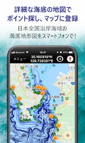
釣りナビくん is a free Android app developed by Marine Networks Co. Ltd. under the Lifestyle category with a focus on Sports subcategory. The app offers a variety of features that make fishing easier and more enjoyable. With the detailed sea bottom maps and GPS functionality of the smartphone, users can now determine the type of terrain their boat is floating on, and even predict where fish might be hiding. The app also offers navigation functionality, allowing users to see their current location on the sea bottom map and displaying their direction, heading, latitude, longitude, and speed. Users can register their favourite fishing spots, record and save their boat's trajectory, and keep track of their catches. Additionally, users can choose to purchase the add-ons, which include Japan's nationwide pinpoint weather information and tide tables and fishing result predictions. The app is further linked to the website, where users can edit and manage registered points and recorded tracks, share fishing results and keep a fishing diary.